Official tourism website for Mourne Mountains and Ring of Gullion
En

Fallows Trail

Shore Road, Rostrevor, County Down, BT34 3AA
The Fallows Trail - view across Carlingford Lough from Rostrevor

Book Tickets Online

About

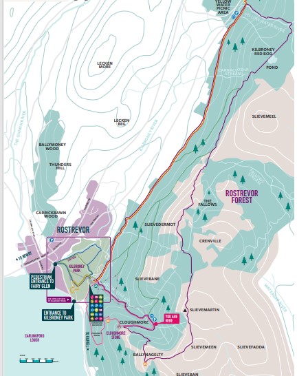
Fallows Trail is a 16.2km loop walk through spruce forests and over mountain slopes. It runs by the Yellow Water River, several streams and Red Bog Lake. There are many wonderful views along the route, such as those over Rostrevor and Carlingford Lough. Fallows Trail is a Category 4 mountain trail with steeper inclines and rugged terrain and follows a combination of existing trails, forest tracks and specially constructed new paths.

Fallows Trail showcases some of the most remarkable views from Ballynagelty viewpoint of Carlingford Lough and the surrounding Mourne Mountains and provides an opportunity to enjoy Rostrevor Forest or to get up close to Cloughmore Stone, a perfect blend of landscape, adventure, and history.

How long is Fallows Trail?

Fallows Trail is a 16.2km loop walk in Rostrevor that is recommended for experienced walkers.

Starting from Kilbroney Park, you will climb steadily up the Cloughmore trail to the Cloughmore Stone and its famous views. Continue ascending until you reach Ballynagelty view point with offers panoramic views of Carlingford Lough and beyond. Descend Slievemeen and ascend towards the summit of Slieve Martin, 485 metres above sea level. Walk past The Fallows Wood towards Slievemeel then around Red Bog Lake and descend the gorge along the Yellow River and follow the Mourne Way back to Kilbroney Park.

What are the highlights along Fallows Trail?

Fallows Trail highlights include ascending the gorge along the river at Yellow Water and the forest trails. There are magnificent views from Slievedermot, Slieve Martin and the Cloughmore Stone.

Flight of the Geese

Around 1900, a couple called Fearon occupied a small farm in the Fallow. They rented it from landowner Albert Canning, whose estate also included what is now Kilbroney Park. The land was high and unsuitable for farming and the couple survived by growing potatoes and some hardy vegetables. They kept a pig and hens and, in order to pay the rent, a flock of geese.

On the day the geese were to be sold in Dundrum Market, the farmer put cold tar on their feet to protect them for the long walk. Unfortunately, he forgot to clip their wings. Having spent their lives in the sheltered hollow, the geese suddenly saw the wide expanse of Carlingford Lough. They flew off, never to be seen again. With the year’s rent now gone, the couple were forced to leave. The remains of the farm are now hidden under the spruce forest in Fallows Wood.

You can enjoy the same exhilarating views as the geese on the Fallows Trail.

Click here to download a copy of the Fallows Trail map.


Fallows Trail Map

TripAdvisor

Add Fallows Trail to your Itinerary

Close window

Call direct on:

Tel +44 (0) 330 137 4046

Map & Directions

What's Nearby

  1. Kilbroney Park features riverside walks and an arboretum. There is a two-mile forest…

    0.1 miles away
  2. This beautiful area has superb views and good walking routes over Carlingford Lough.…

    0.14 miles away
  3. 'Cill Bhronaigh', or Bronagh’s Church (12th century), is located in the graveyard just…

    1.12 miles away
  1. Our play farm offers a huge indoor soft play area with four dragon slides and a massive…

    2.17 miles away
  2. Warrenpoint Beach is located alongside the Mourne Mountains on the shores of Carlingford…

    2.42 miles away
  3. Excellent example of a tower-house and bawn built about 1568 at a point where the Newry…

    3.83 miles away
  4. "Where the Mountains of Mourne sweep down to the sea" (Percy French) The popular song has…

    4.5 miles away
  5. Commanding the mouth of Carlingford Lough, the Castle has an eventful history. It was…

    5.3 miles away
  6. Known locally as the ‘King’s Ring’, this court tomb has a prominent position in the…

    5.45 miles away
  7. Cranfield West offers a gently sloping, mainly sandy beach located at the entrance to…

    6.58 miles away
  8. The Silent Valley Reservoir was built to gather water from the Mourne Mountains and is…

    7.76 miles away
  9. The Electric Brae is a hill at which Newton's discovery, the law of gravity, is defied…

    7.79 miles away
  10. Spelga Dam Reservoir sits in the heart of the Mourne Mountains, located approximately 10…

    7.79 miles away
  11. Kilnassagart Inscribed Stone, in the south of County Armagh, is regarded as being one of…

    7.84 miles away
  12. Corliss Fort is one of the best-preserved bivallate raths in County Armagh.

    7.99 miles away
  13. Leisleitrim Fort is a fine example of a multivallate rath ( a rath with several banks and…

    7.99 miles away
Previous Next

Related

Children enjoying Aslan's Table in Kilbroney ParkKilbroney Park, RostrevorKilbroney Park features riverside walks and an arboretum. There is a two-mile forest drive which showcases panoramic views over Carlingford Lough. There is also a Play Park with children's play area and tennis courts, an Information area and a café all on site.

Family enjoying a BBQ infront of their tent in Kilbroney ParkKilbroney Caravan Park, RostrevorKilbroney Caravan Park is located in Rostrevor, County Down, within 97 acres of beautiful parkland nestle within the backdrop of Slieve Martin and the Mountains of Mourne on the shores of Carlingford Lough.

Map & Directions

Road Directions

Kilbroney Park is located in the village of Rostrevor just off the A2 between Newry and Kilkeel. 

Directions from Belfast to Kilbroney Park (travel takes 60 minutes approximately) : follow the A1 to Newry.  Follow A2 from Newry through Warrenpoint into Rostrevor.  The entrance to Kilbroney Park is on the left. 

Directions from Dublin to Kilbroney Park (travel takes 90 minutes approximately): follow the M1 to Newry.  Take exit for B113 from A1.  Follow A2 from Newry through Warrenpoint into Rostrevor.  The entrance to Kilbroney Park is on the left Postcode: BT34 3AA.

View Maps and Visitor Guides
View what the Mourne Mountains & Ring of Gullion has to offer and some of the best things to see and do during a visit.
E-newsletter sign up
Sign up for the Mourne Mountains & Ring of Gullion newsletter for inspiration and travel tips.
Back to Top

Visit Mourne

Tourism Northern Ireland

Geopark

Don't Miss