Official tourism website for Mourne Mountains and Ring of Gullion
En

Mourne Mountain Walk

Newcastle Visitor Information Centre, 10-14 Central Promenade, Newcastle, County Down, BT33 0AA
Mourne Mountain Walk

Book Tickets Online

About

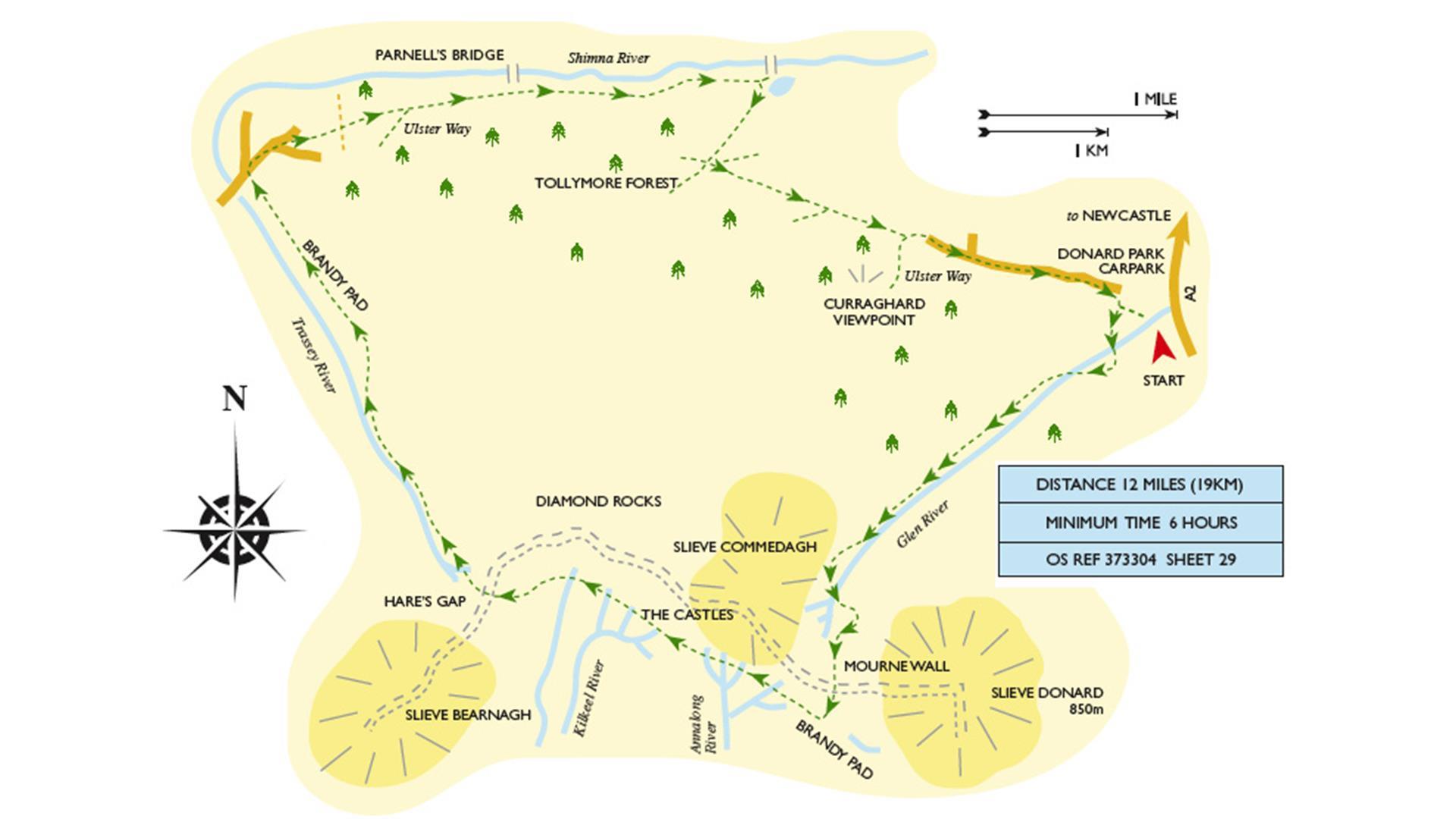
This walk starts at the Donard carpark, Newcastle.

Note the clear unpeaty water of the Glen River, striking rock strata and fine trees. The wood fades away and a granite gravel path runs almost to the great Mourne Wall, built 1904-22 to enclose the catchment area of the Silent Valley which was dammed in the 1920’s.

Look back down the glen to the elegant sweep of the bay. From here to the wall provides a perfect if steep guide to the summit of Slieve Donard, Ulster’s highest peak – not to be missed if the weather is good. Brandy Pad is an old smuggler’s trail. Passing below The Castles (rock towers) look south where isolated granite towers (tors) stand here and there on the ridges. They seem almost man-made. You might be side tracked up 400 ft (120m) to inspect the Diamond Rocks.

Beyond the Hare’s Gap it’s a long tramp along Trassey River. Examine the sheep pens, where strays were probably kept after the hill had been gathered and the sheep sorted out according to their fleece-marks. Now you pass gorse banks, then Ulster Way signs and stiles, hazel coppice, young fir plantation and a fully grown wood of Douglas firs.

Just before Parnell’s Bridge the Ulster Way goes south but you stay with the river bank. Do not cross the bridge but go straight down to the small lake, passing Curraghard viewpoint on your return to the carpark.

Distance:
12 Miles

Time:
6 hours

Terrain:
Mountain

Maps / guides:
Walking Route Cards are available from Newcastle Visitor Information Centre - newcastle.vic@nmandd.org or tel:033 0137 4046

Add Mourne Mountain Walk to your Itinerary

Close window

Call direct on:

Tel +44 (0) 28 4372 2222

Map & Directions

What's Nearby

  1. Newcastle's Parks consist of outdoor facilities at the Castle and Island parks. Castle…

    0 miles away
  2. The Mourne Coastal Route has a few start off points from the County Down coastline,…

    0.01 miles away
  3. The High Mournes Scenic Loop delves into the very heart of the famous Mourne Mountains…

    0.01 miles away
  1. The Shimna River is a river in County Down, Northern Ireland. It rises on the slopes of…

    0.07 miles away
  2. The Mourne Area of Outstanding Natural Beauty is located in the south-east corner of…

    0.1 miles away
  3. The Mourne Wall is 22 miles long and consists of natural granite stone which was…

    0.29 miles away
  4. Donard park is a beautiful park located in the lovely town of Newcastle County Down, next…

    0.32 miles away
  5. Newcastle Beach is a popular seaside resort and tourist destination located on the South…

    0.35 miles away
  6. Newcastle is a small drying harbour with fixed fore/aft moorings and consists of two…

    0.49 miles away
  7. Maghera Church and Round Tower is of major historical importance and is among many…

    1.96 miles away
  8. This 5 mile stretch of golden sands is still the essence of the resort and is hugely…

    2.03 miles away
  9. Tollymore Forest Park has panoramic views of the surrounding mountains and the sea at…

    2.23 miles away
  10. Murlough National Nature Reserve is a fragile 6000 year old sand dune system owned by the…

    2.54 miles away
  11. The Maize Maze is the only one of its kind in Northern Ireland. A massive 6 acre field of…

    3.16 miles away
  12. Set in spectacular surroundings overlooking Dundrum inner Bay these fine Georgian…

    3.61 miles away
  13. A small car park for visitors is located off the Drumnaquoile Road and an extensive…

    3.92 miles away
Previous Next

Map & Directions

View Maps and Visitor Guides
View what the Mourne Mountains & Ring of Gullion has to offer and some of the best things to see and do during a visit.
E-newsletter sign up
Sign up for the Mourne Mountains & Ring of Gullion newsletter for inspiration and travel tips.
Back to Top

Visit Mourne

Tourism Northern Ireland

Geopark

Don't Miss