Official tourism website for Mourne Mountains and Ring of Gullion
En

Narrow Water Keep Warrenpoint

Newry Road, Warrenpoint, County Down, BT34 3LE
Narrow Water Keep  Warrenpoint

Book Tickets Online

About

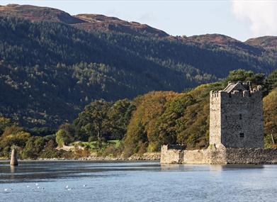
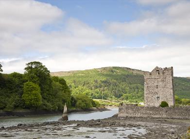
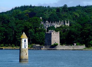
Excellent example of a tower-house and bawn built about 1568 at a point where the Newry River meets Carlingford Lough, a strategic spot.

There has been a keep on this site since 1212. It was originally built by Hugh de Lacy, first Earl of Ulster, to prevent attacks on Newry via the river, as part of the area's Norman fortifications. The original was destroyed in the 1641 Rebellion.

(Children under 16 years must be accompanied by an adult).

Facilities

Provider Preferences

  • Free (parking charges may apply)

Guide Prices

Ticket TypeTicket Tariff
TicketFree

Please contact the organiser for any further information that's required.

Add Narrow Water Keep  Warrenpoint to your Itinerary

Close window

Call direct on:

Tel +44 (0) 28 9082 3207

Map & Directions

Opening Times

* Open Friday, Saturday and Sunday, 9.30am - 5.00pm, last admission 4.30pm, until end of September.

What's Nearby

  1. Warrenpoint Beach is located alongside the Mourne Mountains on the shores of Carlingford…

    1.52 miles away
  2. Known locally as the ‘King’s Ring’, this court tomb has a prominent position in the…

    1.66 miles away
  3. Our play farm offers a huge indoor soft play area with four dragon slides and a massive…

    1.75 miles away
  1. Kilbroney Park features riverside walks and an arboretum. There is a two-mile forest…

    3.73 miles away
  2. 'Cill Bhronaigh', or Bronagh’s Church (12th century), is located in the graveyard just…

    3.88 miles away
  3. This beautiful area has superb views and good walking routes over Carlingford Lough.…

    3.89 miles away
  4. This monument is an extremely well preserved Neolithic burial site with three chambers. …

    4.71 miles away
  5. Kilnassagart Inscribed Stone, in the south of County Armagh, is regarded as being one of…

    4.83 miles away
  6. Corliss Fort is one of the best-preserved bivallate raths in County Armagh.

    4.84 miles away
  7. Dating from the Iron Age period around 10 BC, the enclosure comprises two roughly…

    4.84 miles away
  8. Leisleitrim Fort is a fine example of a multivallate rath ( a rath with several banks and…

    4.84 miles away
  9. Bagenal’s Castle located in historic Newry is a 16th century fortified house and…

    4.84 miles away
  10. This is undoubtedly the most commanding building in Newry and is arguably the most…

    4.97 miles away
  11. This unusual megalithic monument is set on the eastern edge of a low ridge, overlooked by…

    4.99 miles away
  12. Follow Fionn's Giant Adventure (previously known as the Giant's Lair) at Slieve Gullion…

    5.09 miles away
  13. The Slieve Gullion Forest Trail, a magnificent 10km Scenic Forest Drive will be…

    5.09 miles away
Previous Next

Map & Directions

Road Directions

Directions from Town:5 miles (8km) south-east of Newry beside the A2 to Warrenpoint.

View Maps and Visitor Guides
View what the Mourne Mountains & Ring of Gullion has to offer and some of the best things to see and do during a visit.
E-newsletter sign up
Sign up for the Mourne Mountains & Ring of Gullion newsletter for inspiration and travel tips.
Back to Top

Visit Mourne

Tourism Northern Ireland

Geopark

>

Don't Miss